
Rangitoto Island was created in the Hauraki Gulf about 700
years ago by volcanic eruptions; it is the youngest of 48 Auckland volcanic
cones. The circular island rises 853 feet from the water surface; it covers
2311 hectares and is rich in 200 species of plants and trees including the
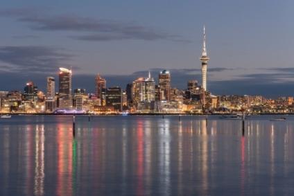
largest Pohutukawa forest in the world. Rangitoto can be seen off the coast of Auckland about
5 miles northeast of the city. The island is connected to Motutapu Island by a
causeway. The island has been a recreation reserve since 1890 and for
approximately 30 years the volcanic scoria was quarried and shipped to
Auckland. From 1925 to 1936 prisoners were brought to the island to construct
roads and a track to the summit.
During the 1920s and 1930s bach communities were built on
Rangitoto Wharf, Islington Bay and Beacon Head. The buildings were constructed
with scarce resources and included communal facilities like tennis courts and a
community hall. What has remained of these structures is extremely important in
New Zealand’s history as other bach communities throughout the country have
almost completely disappeared. You can visit the Bach 38 Museum (by
appointment) and take a guided tour. A “bach” was a modest type of 20th
century New Zealand beach home usually on or near the beach. The name may have
come from “bachelor pad” or from the Welsh for “small.” By 1937 there
were 140 baches in Rangitoto’s three bach communities.
Visitors can reach the island by ferry and then enjoy the
many walking paths around the island; if you reach the summit there are great
views of Auckland city across the Hauraki Gulf. You can take the guided
Volcanic Explorer Road Train to the summit. One of the most fascinating stops
along the route to the summit is the black lava caves. There are also sea kayak
excursions off the coast of the island and even a night kayak tour.


Visit A City is all about the fun of planning the details of your trip. We believe that your own personal trip requires you to have your own personal travel guide.
Starting with one of our adjustable guides is the easiest way to decide what to do, where to dine and where to put your head down after an enjoyable day.
Planning a trip was never this easy!
2014-2025 © All Rights Reserved. Privacy Policy | Terms of Service